Solving a single shot
A range card answers “what about every range, in a 10 mph crosswind”. The firing solution answers the question you actually have on the mat: what do I dial for this shot? Enter the range, the angle and the wind as it is now, and it gives you the elevation and windage for that one shot, worked out from the card you have loaded.
Opening it
Build or load a card in the range card builder first — the solution uses everything on it: the load, the zero, the sight height, the environment and the MIL or MOA setting. It needs at least a muzzle velocity, a ballistic coefficient and a zero distance, and says so if one is missing.
- On a phone, press Solve on the bar at the bottom of the screen.
- On a wider screen, press Solve shot above the card preview.
It opens full screen, with nothing else on it, and keeps the screen awake while it is open so the phone doesn’t lock between shots. Press the × or Esc to go back to the card.
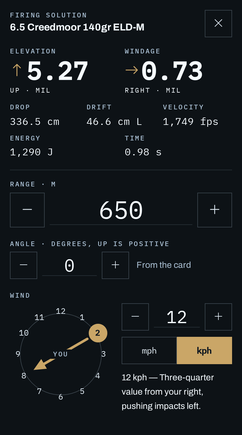
Entering the shot
The answer sits at the top of the screen and updates as you change anything below it. Every field has − and + buttons big enough to use with gloves, so you rarely need the keyboard.
| Range | The distance to the target, in the card’s unit (metres or yards). The buttons step it by 10. On an angled shot this is the line-of-sight distance — what a rangefinder reads — and the label says so. |
|---|---|
| Angle | Degrees up (positive) or down (negative) to the target. It starts at the card’s shooting angle, marked From the card. Change it for this shot and a Card’s …° button appears to put it back. The buttons step it by 1°, and the field takes anything from −80° to 80°. |
| Wind direction | Tap the clock position the wind is blowing from, with the target at 12 o’clock and you in the middle. The arrow shows the way the wind is travelling, and the sentence underneath spells out what it does — “Three-quarter value from your right, pushing impacts left”. Tap the chosen position again to clear it. This is the same dial as the logbook . |
| Wind speed | In mph or kph — pick with the toggle beneath it. No speed, or no direction, means still air. |
Reading the answer
The two big numbers are what to dial, in the card’s MIL or MOA, and each carries the direction to turn the turret: Up or Down for elevation, Left or Right for windage. The direction is the one people reverse under pressure, so it is written out and drawn as an arrow rather than left to a plus or minus sign.
If you hold rather than dial, hold the same amount the same way: 0.73 right means aim 0.73 mil right of the target. A correction smaller than half a click on a fine turret reads Hold — there is nothing to dial.
| Drop | How far below the line of sight the bullet has fallen at the target. |
|---|---|
| Drift | How far the wind (and spin drift, if the card has a barrel twist, and Coriolis, if it is on) moves the bullet sideways, with the side it moves to. |
| Velocity | Remaining velocity at the target, in the card’s muzzle velocity unit. |
| Energy | Remaining energy at the target — joules on a metric card, ft·lb on an imperial one. |
| Time | Time of flight in seconds — how long the wind has to work on the bullet. |
How it differs from the card
The printed card assumes a full-value crosswind — one blowing straight across the range — at a few fixed speeds. Real wind rarely does that, which is why shooters learn to take a fraction of the card’s wind figure by eye. The firing solution does that part for you by solving the shot with the wind at its actual angle:
- A wind from 2 or 10 o’clock counts for about 0.87 of full value, and one from 1 or 11 o’clock for half.
- A head or tail wind has no sideways push, but it does change the elevation slightly — the card ignores that; this doesn’t.
- Any range can be solved, not just the rows on the card, so there is no reading between two lines.
- Uphill and downhill shots need less elevation than the same distance on the level. The solution assumes your rifle was zeroed on flat ground and fires the shot at the angle you give it.
The answer is only as good as the card behind it. If your impacts don’t match at distance, true the card against real results first — every solution after that benefits.
Coriolis (optional)
The Earth turns under the bullet while it flies. That moves the impact in two ways: sideways by an amount set by your latitude, and up or down by an amount set by your latitude and the direction you are firing in. Measured on a 6.5 Creedmoor at 2710 fps, in MIL:
| 51.5° N (London), any direction | 500 m: 0.04 R 1000 m: 0.09 R 1500 m: 0.15 R |
|---|---|
| 51.5° N, firing east (plus the drift above) | 500 m: 0.03 high 1000 m: 0.07 high 1500 m: 0.12 high |
| 51.5° N, firing west (plus the drift above) | 500 m: 0.03 low 1000 m: 0.07 low 1500 m: 0.12 low |
| 33.9° S (Sydney), firing east | 500 m: 0.03 L, 0.03 high 1000 m: 0.06 L, 0.09 high 1500 m: 0.11 L, 0.15 high |
| Equator, firing east | 500 m: 0.04 high 1000 m: 0.10 high 1500 m: 0.19 high |
The drift is to the right in the northern hemisphere and to the left in the southern, whichever way you face. Firing east lands high and firing west lands low; north or south has no vertical effect. At 1000 m that is about one click on a 0.1 MIL turret. Under about 600 m it is smaller than the error in any wind call, which is why it is off unless you turn it on.
Tap Coriolis below the wind to open it. Open means on and closed means off, so it can’t be left on out of sight. Then enter:
| Latitude | How far north or south of the equator you are, with N or S beside it. Use my location fills it from your phone — only when you tap it, and only the latitude, to a tenth of a degree, is kept. |
|---|---|
| Direction of fire | Optional. The compass bearing to the target, 0 to 359° from north. Without it you get the sideways drift only, which is slightly overstated but within a hundredth or two of a MIL. |
Longitude doesn’t matter: the effect depends on how far you are from the equator, not where you are around it. Nor does true versus magnetic north: a few degrees of declination changes the answer by well under a hundredth of a MIL, so any compass, including the one on your phone, will do.
The dial at the top includes Coriolis while it is on, and the line under the fields says how much of it is Coriolis — or “Under a click” when there is nothing worth dialling. Your zero is left as it is: over 100 m the effect is under a thousandth of a MIL, and your rifle’s measured zero already includes whatever your home range did to it. The printed range card never includes Coriolis, because it is meant to work anywhere.
What it remembers
The last range, wind speed, unit and direction are kept on this device and filled back in the next time you open it, whichever card is loaded — the wind is the same wind whatever rifle you pick up. A range from a metric card is converted if you open it on a yards card. Coriolis stays on or off as you left it, with its latitude and direction of fire.
The angle is not remembered. It belongs to one target, and it goes back to the card’s angle every time you open the solution, so a steep shot from earlier can’t quietly carry over to the next.